Exercise 06: Completeness II - Mapping Saturation#
Motivation#
Exploring how OpenStreetMap data developed over time across different administrative units might reveal interesting insights into the self organizing approach of the OSM communities and can potentially be used to derive intrinsic data quality indicators. It might even be possible to estimate the completeness of OSM for a specific key-value combination as done by [Barrington-Leigh and Millard-Ball, 2017] for the road network.
[Brückner et al., 2021] have estimated the completeness of the number of OpenStreetMap (OSM) retail stores for two federal states of Germany at district level. In their work they have used an intrinsic measurement that fits saturation models on the cumulative curve of the number of OSM retail stores over time.
“The underlying idea of the intrinsic completeness analysis is that the added number of OSM objects of a specific feature class per time period decreases as the number of mapped objects converges against the (unknown) true number of objects. The cumulative number of OSM objects would then saturate. Given a sufficient mapping activity it is possible to estimate the saturation level using a suitable function in the context of a non-linear regression approach.” [Brückner et al., 2021]
Exploring OSM history: the example of health related amenities#
Note
This section is partly based on a blog post created by Sven Lautenbach.
In this exercise we want to investigate the development of health related amenities across countries. The figure below shows the healthcare related mapping activity in OSM in India.
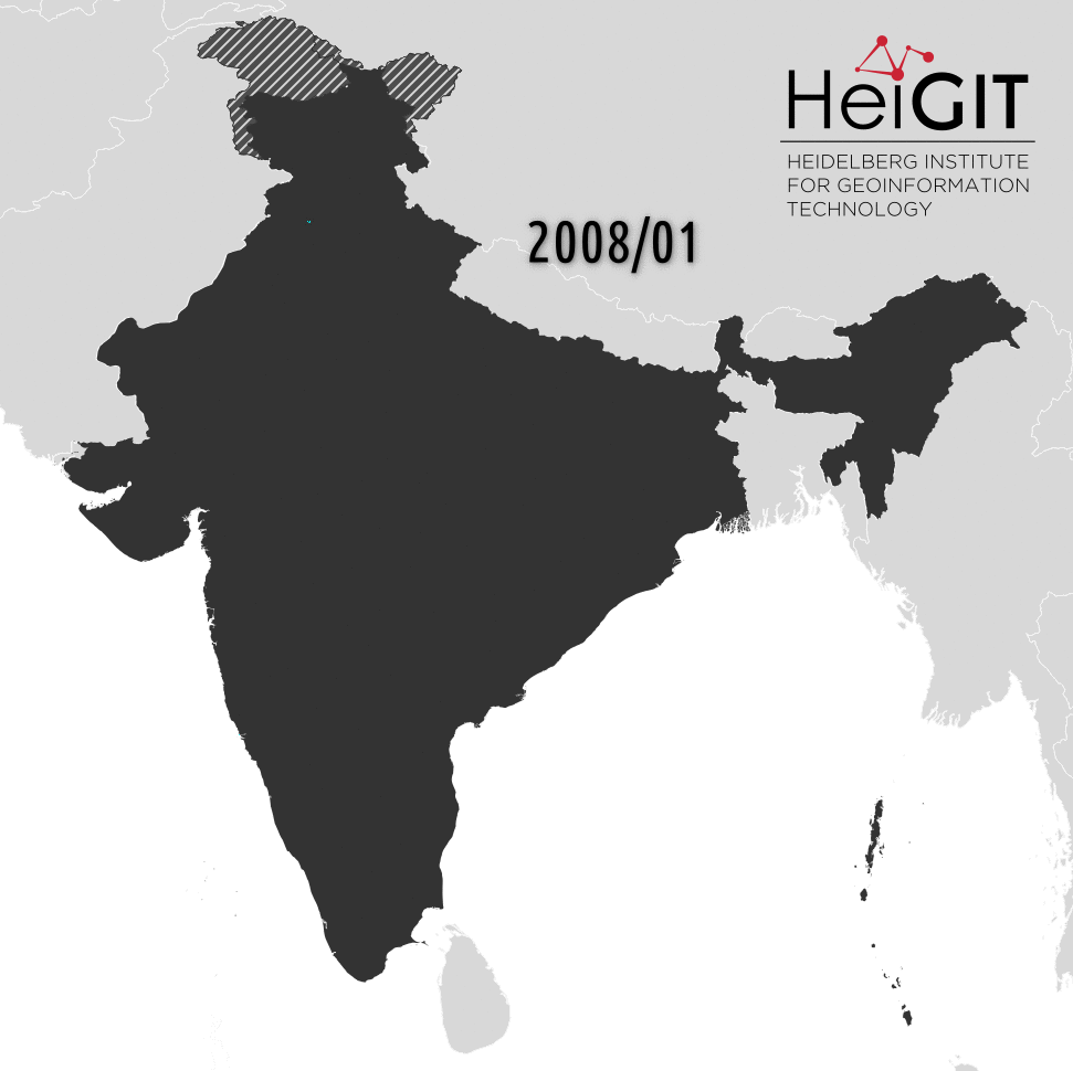
Fig. 27 OSM health care facilities in India over time#
Compare the temporal evolution of hospital data in OSM#
Use the ohsome API to visualize the number of hospitals mapped in OSM since 2008-01-01 per month for the following countries:
Germany
Romania
Haiti
Lesotho
China
India
Download country the country boundaries from Natural Earth. Using simplified geometries (scale 1:10 Million) will speed up the ohsome API queries compared to higher resolution polygons.
Use the simplified geometries and the following filter amenity=hospital or healthcare=hospital to query the ohsome API /elements/count endpoint.
Show Python Code.
import pandas as pd
import geopandas as gpd
from ohsome import OhsomeClient
client = OhsomeClient()


country_names = [
    "India",
    "China",
    "Germany",
    "Romania",
    "Haiti",
    "Lesotho"
]

# load the geojson file with geopandas
bpolys = gpd.read_file("../../data/ne_10m_admin_0_countries.shp")
bpolys = bpolys[bpolys["NAME"].isin(country_names)]

# here we create an additonal colum "boundary" to be used as the new index
# it is important that this column contains string values
bpolys["boundary"] = "region_" + bpolys.index.astype(str)
bpolys.set_index("boundary", inplace=True)

# Define which OSM features should be considered.
tag_filter = "amenity=hospital or healthcare=hospital"

# Define the time range and time interval
time_range = "2008-01-01/2023-11-01/P1M"

# Here we do not set the timestamps parameters.
# This defaults to the most recent timestamp available.
response = client.elements.count.groupByBoundary.post(
    bpolys=bpolys,
    filter=tag_filter,
    time=time_range
)

# display results as dataframe
results_df = response.as_dataframe()

# join results dataframe and input dataframe
# here we only join the name of the region to the results
join_df = results_df.join(bpolys["NAME"])
display(join_df)
Create a plot for each country using the matplotlib library.
Show Python Code.
import matplotlib.pyplot as plt


for country in country_names:
    country_df = join_df[join_df["NAME"] == country].copy()
    country_df.reset_index(inplace=True)

    plt.figure()
    plt.plot(
        country_df["timestamp"],
        country_df["value"]
    )
    plt.ylabel("count")
    plt.title(country)
    plt.show()
Estimate the completeness with the mapping saturation indicator#
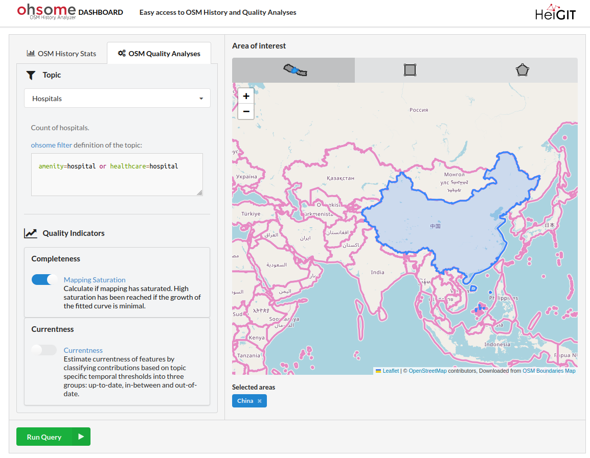
The ohsome dashboard allows you to estimate the completeness of OSM data using the mapping saturation approach.
Use the ohsome dashboard to calculate the mapping saturation for hospitals in the selected countries.
Show Steps in ohsome dashboard.
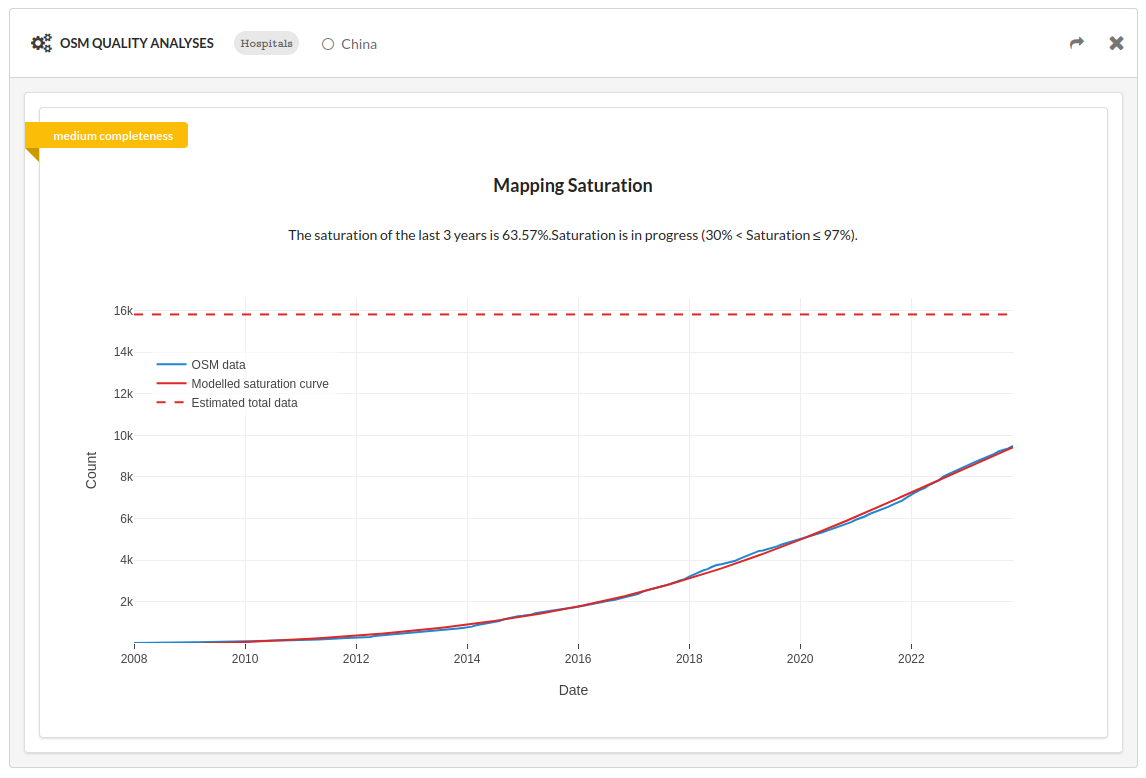
Discuss the results of the mapping saturation indicator. Consider the following aspects:
Can you always trust this indicator? (In which of your countries not?)
Are there differences in hospital mapping/tagging in OSM?
Why are numbers for hospitals decreasing in some countries?